Bob Leverett, old-growth forest guru, and wife Monica share their account of a trip taken through part of the southern Appalachian mountains with botanist friend Jared Lockwood. All photos courtesy of Bob Leverett, except as noted.
Introduction
We take great pleasure in sharing our
summer travels with good friends. On June 13th we set out on a
trip to Bob’s cherished southern mountain homeland, a region that
Monica is fast adopting. In fact, Monica has become Bob’s match in
appreciating the area’s tranquil beauty and natural and cultural
richness. She now claims the Blue Ridge Parkway as one of her
favorite drives of all. At the start of the trip, it was a
twosome (Monica and Bob), but our friend Jared Lockwood joined us in
Appomattox, VA, and then we were three.
This trip report has been written jointly by Bob and Monica. Consequently, we speak as a team, except where the message comes from or is about one or the other. In those cases, we use the first name of the subject.
This trip report has been written jointly by Bob and Monica. Consequently, we speak as a team, except where the message comes from or is about one or the other. In those cases, we use the first name of the subject.
On the Way - Tuesday June 13th
We left Florence, MA about noon on a
sunny day – perfect weather for traveling. First was a stopover at
Northampton Coffee for our traditional send-off lattes. The latte is
a mood enhancer for both of us, but especially Monica. With her, it
is not optional. So, with latte froth on our lips, we rolled down
I-91 south to the Mass Pike and then snaked our way west across the
Berkshires, south on New York’s Taconic Parkway, west across I-84
to Scranton, PA, and finally, south on I-81 to Hazleton, PA and the
Hampton Inn. It is a route we have taken many times.
Along the way we have our favored
spots. For example, in Massachusetts, one of our place markers is the
summit spot on I-90 at 1,724 feet above mean sea level. You have to
travel all the way to Oacoma, South Dakota to reach a higher
elevation on that Interstate (we’ve been there, done that). The
fact that the eastern high point of I-90 is in Massachusetts is a
source of pride for Bob, a confessed captive of statistics and
numerical comparisons.
We left I-90 at Austerlitz, NY and
started down the Taconic Parkway from its northern end. Although
the Parkway runs for 104.8 miles, we generally leave it at I-84.
Place markers for us are mainly the rest stops, which offer views of
New York’s Catskills to the west across the Hudson Valley. In New
York, the Parkway route down the Taconic Mountains is topographically
across a rolling upland with pleasing contours. The countryside was
heavily farmed and is generously sprinkled with names of Dutch
origin. By contrast, the Catskills rise boldly above the near
sea-level Hudson Valley, appearing higher than they actually are.
There are two peaks over 4,000 feet above sea level, and 35 above
3,500 feet.
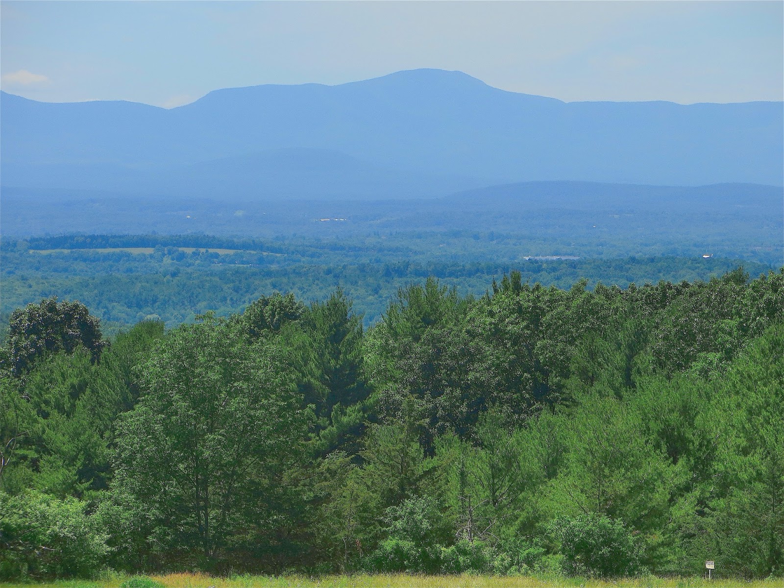
Below is a view of the Catskills from a
Taconic Parkway rest stop. When viewing those dreamy summits, Bob’s
thoughts often turn to Washington Irving’s Rip Van Winkle. For us, there was no time for a 20-year nap,
but we enjoy discussing our past forays into the Van Winkle country
and the hikes up spots like hellishly steep Plateau Mountain.
 |
| Kaaterskill High Peak |
In the image, the Catskills rise
dramatically above the Hudson River lowlands. The peak in the center
of the image is 3655-foot Kaaterskill High Peak, once thought to be
the highest mountain in the Catskills.
Looking across the Hudson Valley, it is easy to see why. The peak
rises 3,350 feet above its base near Manorville in only 2.7 miles.
There is no trail leading to the summit from Manorville. Hikers using
the official trail network have much higher starting points.
Farther along, we stopped at A Taste of
New York. It’s where Bob gets his sugar high from their delicious
homemade pastries. One lady remembered Bob as the tree guy. His head
instantly grew two sizes, and almost wouldn’t fit through the door.
Despite the familiarity of the route,
there was actually a surprise on day #1. It was a beautiful view of
the Wyoming Valley experienced from the patio of our Inn. Scranton
and Wilkes Barre, PA are located at the north end of the valley.
There’s little that is attractive to us in the long urban stretch.
The surrounding ridges reflect their past as sources of anthracite
coal. After years of mining, the ridges have been left barren. The
vegetation is very scrubby. The land has literally been leached of
virtually all life. But farther south, conditions improve a bit. The
traveler is treated to a verdant valley surrounded by long parallel
ridges and a single conically shaped peak. We enjoyed this
exceptional view from our Inn accommodations – a decided relief
from the usual storefronts and parking lot views one gets from most
motels along the Interstate corridors.
We ate on their deck from our cooler,
taking in the view to the west. Our traveling meals are highly
nutritious – basically salads using only organic ingredients. We
stock up on them before each trip from our River Valley Coop.
Below are two images that capture some
of the panorama that stretched out before us. The second image shows
a conical peak with houses encroaching on its base and a power line
going across a shoulder. In the 1980s, there were none of these human
structures. Elevation from our deck was 1,516 feet above sea level.
The valley lies at an elevation of about 1,000 feet or 500 vertical
feet below us.
 |
| Hazleton, PA |
 |
| Hazleton, PA |
After eating our dinner, we retired. The next morning, we enjoyed a great breakfast – a rarity for Inns. We vowed to return to Hazleton’s Hampton Inn on future visits south.
Inn at Sugar Hollow - Wednesday June 14th
We drove all day, dodging the heavy
truck traffic of I-81 and impatient drivers going nowhere, but bent
on getting there in record time. Compared to when Bob remembers
traveling it in the 1980s, I-81 is now a handful, but still
preferable to I-95 with its perpetually packed lanes.
Down I-81 to Staunton, VA and across
the Blue Ridge on I-64, we arrived tired at the mercifully secluded
Inn at Sugar Hollow Farm, located at the foot of Virginia’s
Shenandoah National Park. We were given the Wildflower Room, their
most expensive accommodation, for the price of the least expensive
room. We were their only guests. We enjoyed Shiloh and Mandy, parents
of Bonnie and Clyde (all four-legged canines with an abundance of
energy and curiosity).
Blue Ridge Parkway and Appomattox - Thursday June 15th
After an ample breakfast at the Inn,
enjoyed with a view to the high mountain ridgeline that includes the
Shenandoah National Park, we said goodbye to our host and hostess and
headed back west to pick up the Blue Ridge Parkway at Rockfish Gap -
its northern beginning. We turned our car onto that
thin gray ribbon in the sky, and tranquility returned. Monica has
described this in her recent brief essay on the Parkway as a
spiritual experience.
A short distance on the Parkway, we
stopped to gaze eastward down into the piedmont from where we had
just come. Clouds hovered just above the ridge we were on, creating a
sunlit window into the Afton valley about 1,000 vertical feet below.
A mountain laurel that had passed its prime created a color contrast
to the grays, greens, and blues. The photographic possibilities along
the Parkway are endless. Accomplished photographers routinely match
their skills against the range of features and colors. Some attempt
to capture what the eye sees while others rely on heavy filters to
change the colors and clarity of land features. Our preference is
the former.
 |
| Afton Overlook - Blue Ridge |
We drove along casually, Parkway style,
to capture what can be a transcendental driving experience. Cruising
the BRP by car or motorcycle is meant to be an exploration of what
becomes poetry in motion at just the right speed - the intention of
its designers. You move across the mountain contours and around the
gentle curves. You flow with them, not attack them. Every mile is a
visual feast with the driver integrated into the scene. It is an
exercise in cooperation and integration, as opposed to conquest. For
mile after mile, the
overlapping crowns of trees create
green tunnels that you gently thread your way through until an
overlook beckons you to stop and sample the ingredients of another
visual feast.
Some Parkway stops have become
traditional for us (e.g. Twenty Minute Cliff). Here is a view from
the overlook. The boughs are of a table mountain pine, one of our
favorite species.
 |
| Twenty Minute Cliff |
Although most of our experiences place
nature at the center, one stop netted us an unexpected
cultural/historical bonus. At Humpback Rocks Visitor Center we met
the lady who runs the center. It turns out that she grew up on the
Parkway. Her father was one of its builders: he helped rebuild the
James River Canal, and was part of the construction of Abbott Lake
below Sharp Top Mountain. She knew Carlton Abbott, son of Stanley W.
Abbott (for whom the lake is named), a main designer of the parkway.
We regretted that we did not get her on video; she had a great
Virginia accent and lots of stories to tell.
We heard other stories from locations
where we commonly meet hikers of the Appalachian Trail. Thunder Ridge
offered us not only entertaining accounts of the hikers, but a
sweeping panorama. Here is part of what we saw.
 |
| From Thunder Ridge |
We then drove to around milepost 86 at
the popular Peaks of Otter. We had to exit the Parkway sooner than
we’d have wished because our destination was the Appomattox Inn and
Suites and we had to make it by mid-afternoon. This Inn is also a
good place to stay, and it offers a bonus: it is near the historic
Appomattox Courthouse of Civil War fame.
We visited the Historic Park and saw
McLean House, where the surrender was signed to end the Civil War.
Interestingly, Lee’s table, where he sat, was larger than Grant’s.
We wondered about that. Compare them in the photos:
 |
| Grant's Table |
 |
| Lee's Table |
We watched the National Park Service’s excellent 15-minute film. It was very moving.
Back at the Inn, our friend Jared
Lockwood from Massachusetts met us. He went to the cemetery, and saw
a tombstone for a Confederate soldier who had fought in the war for
1400 days, and was killed on the last day. There’s lots of food for
thought at Appomattox. The setting is pastoral and relaxing, but
though it symbolizes the end of our bloodiest war, it still was a
battlefield where over 700 soldiers died.
Tree Measuring Workshop - Friday June 16th
We attended a tree-measuring workshop
at Patrick Henry’s Red Hill Plantation sponsored by the Virginia
Champion Tree Program and the American Forests National Cadre. Dr.
Eric Wiseman, a Virginia Tech Associate Professor, was the primary
organizer of the event. Bob was the principal presenter. A total of
17 people attended. Eliza Kretzmann and Justin Hynicka, the two new
national co-Coordinators came.
Bob’s presentations, on behalf of
American Forests, were on tree-measuring methods applicable to
certifying champion trees. The techniques are highly mathematical,
but Bob has found ways to create Excel spreadsheets to be filled in
with a few measurements, making complicated computations available to
everyone.
After the lectures, the group had lunch
and then went to measure the historic Osage orange tree located on the
plantation. It is the national champion, and the folks at the
plantation are mighty proud of it. It is a monster, but is not one tree
(in the context of "one trunk equals one tree"). It is a tree-organism.
Bob deferred to Eric to decide what to do. Eric wanted to establish a
protocol for re-measuring the tree. The remainder of the time around
the tree was devoted to sightings on the trunk for taking
measurements, and discussions. Eliza and Justin got to hear about
some of the tough issues associated with administering the National
Register. A good time was had by all. Here is a look at the
multi-trunked Osage orange.
 |
| Osage Orange |
On leaving Patrick Henry’s historic
plantation, we meandered across the Virginia countryside to
Martinsville to a Comfort Inn. The Virginia piedmont is pastoral and
very pleasant to the eye. There are lots of green fields bordered by
white fences in good repair.
The Comfort Inn is okay for the price,
and the management really wants to please, but its location isn’t
especially inviting. Its breakfast offering was a big step down from
the Hazleton Hampton Inn.
Back to the Parkway - Saturday June 17th
From Martinsville, we took back roads
to the Blue Ridge Parkway (BRP), and on the way, we found a fabulous
farm stand (Po’ boy Farm stand) about 5 miles south of Meadows of
Dan, maybe in Vespa, VA. We loaded up on great farm cheese and
peaches. Bob proclaimed the cheese the best he had ever eaten. Oh
yes, there was an abundance of Confederate flags around – goes with
the territory. Once on the Parkway, we stopped at Mabry Mill
(milepost 176), and took the requisite classic photos of the water
wheel. The Mill was crowded, and Bob forewent his much valued
blackberry cobbler. We wound our way down the BRP, stopping at
various overlooks.
This was Jared’s initiation to the
Parkway. As a botanist, he was instantly interested in every plant he
saw. At an overlook, Monica met a Canadian motorcyclist from Ottawa
and gave him points on where to stay and what to see. He shared an
interesting interpretation of Parkway driving – more tiring than
Interstates. It is constantly negotiating curves and looking out for
deer.
For us, the highlight of this segment
of the Parkway occurs around milepost 244. We like to picnic at a
fabulous spot named Doughton Park, which sets at about 3,700 feet
elevation on the high Blue Ridge plateau. Picturesque table mountain
pines, blooming mountain laurel, grassy meadows, cooling breezes, and
enchanting views of the surrounding Blue Ridge make Doughton a
routine stop for us. Its meadows offer peace and serenity.
Fritillary butterflies are abundant.
In the image below, we see a table
mountain pine, a symbol of uplands in this part of the Parkway. The
shrub in front and to the left of the pine is a mountain laurel that
has gone by. There were plenty at the peak of bloom, but they were in
the shade.
 |
| Table Mtn Pine at Doughton Park |
The part of the Parkway we were driving
(south of Mabry Mill) meanders across the high Appalachian plateau.
Travelers are not always aware of their elevation - unless they read
the signs. They may even think they have exited the mountains until
the Parkway swings near an escarpment with dramatic views down into a
valley and across the ridges beyond. The sudden change from rolling
terrain to breathtaking panoramas offers unlimited photographic
opportunities, but in recent years, increasing pollution often
obscures the features that the photographer wants to capture.
Scenes of mountains with clouds
floating above and below are Bob’s perennial favorites. He loves
the flowing forms of the ridges and their range of hues. For him,
these are the signature features of the Blue Ridge. Case in point is
the view in the next scene. Note the white pine on the right of the
image.
 |
Past the Moses Cone Memorial Forest, the terrain changes. A hulking landform appears, as the Parkway approaches one of the most special mountains in the entire eastern United States. Near milepost 300, the Parkway negotiates the shoulder of lofty 5,946-foot high Grandfather Mountain featuring the famous Linn Cove Viaduct. What visitors are unaware of is that the road passes through a swath of old growth forest. The only clue to the change from predominantly younger re-growth woodlands is the shaggier appearance and greater texture that the eye sees. There is more crown differentiation with the older trees.
The vistas from Grandfather’s
shoulder are of seemingly endless mountains. The rock cliffs on
Grandfather are spectacular and some of them were featured (totally
inappropriately) in the movie Last of the Mohicans.
By 6:30PM, we reached Linville and the
Pixie Inn, an inexpensive, but clean motel that allows you to meet
local folks. The desk clerk was quite a talker. We got the motel’s
full history. Later, we introduced Jared to Old Marston Mill for
dinner, with folk singer and karaoke backup. It isn’t bad, and it
is convenient, and the décor is truly original with memorabilia
displayed in every spot. Here is a scene from a previous visit.
Monica squeezes lemon to make her lemon water – a far cry from the
favorite beverage of the region in the 1950s: notice the Royal Crown
Cola sign on the wall.
 |
| Monica at Old Marston Mill |
Back at the motel, we met Sophie the Chihuahua, who at first barked at us, then got used to us, and finally adopted us.
Grandfather Mountain and Linville Gorge - Sunday June 18th
We began the day with breakfast at a
Scottish restaurant. Bob talked Jared into ordering country ham,
neglecting to explain that one serving of that southern mountain
staple gives one his entire annual quota of salt - very efficient.
We observed Jared’s eyes widen as if his insides were becoming as
cured as the ham had been. Fortunately, he didn’t turn into a
pillar of salt. The salt-cured ham didn’t faze Bob. His insides
were cured years ago.
We then drove part way up Grandfather
Mountain into the state park to share its botanical and scenic
treasures with Jared. Grandfather is a UNESCO International
Biosphere Reserve, which about says it all. For example, the very
rare pink-shell azalea finds a home on Grandfather. Its native
habitat is the high elevation meadows, bogs, and spruce forests of
the North Carolina mountains.
The mountain is a bundle of
superlatives, and it offers them through a distinct personality.
However, on the 18th, there were lots of people, and many,
if not most, seemed to be searching for some kind of diversionary
entertainment. They can get it on the famous mile-high swinging
bridge. Bob and Jared joined the crowd. The temperature was mild and
there wasn’t any wind, so the crossing was easy. On Grandfather,
the weather is notoriously changeable, and people are not allowed on
the bridge in high winds.
We then headed down to the nature
museum and restaurant. It too was crowded with people, who were
financially supporting the mountain, a fact not to be forgotten.
Most of our photos are of vistas, but
as a change of pace, here is an intimate shot of plant life on
Grandfather. The Galax was blooming.
 |
| Galax Flowering on Grandfather Mountain |
Then it was off to scenic Linville
Gorge (milepost 316). Like Grandfather, Linville has many
exceptional natural features. For example, it is advertised as the
East’s deepest gorge, although it has competition from a number of
other contenders. Its depth varies, but averages between 1400 and
1600 feet from rim to river. People go to several observation points
to look off into Linville’s depths and to enjoy its waterfalls. A
couple of trails go to the bottom of the gorge. Most visitors never
learn of its 10,000 acres of old growth forest, and it is one of the
places you can see Carolina hemlocks, a species with a very limited
range.
As we walked up the trail to the upper
falls, Linville’s old growth felt especially welcoming to Monica.
The ancient trees lining the trail have witnessed generations of
visitors come and go. These old arboreal stalwarts project a kind of
accumulated wisdom, perhaps shared by all ancient beings. The Ents of
Tolkien exemplify this tree-based wisdom. Wisdom acknowledged, still
in all things tree, a little measuring must occur.
Bob and Jared re-measured a 148-foot,
300-year old white pine right on the trail that Bob had measured
years ago with a homemade measuring device. This time, Jared had the
final say with his TruPulse 200X laser rangefinder. His measurement added 4 more inches
to the Drinking Straw Pine, as Jared named it. We won’t further
describe Bob’s homemade measuring device, but you now know one of
its components.
The following image is typical of the
Linville Gorge old growth. Eastern hemlocks and white pines thrust
their straight trunks through a thick understory of rhododendron and
laurel. They are easy to identify as old trees.
Less so are the hardwoods, including species like Fraser magnolia,
which shows off its creamy white blossoms in early May.
In the image, the blue paint identifies
a hemlock being treated to kill the hemlock woolly adelgid insect. Without
treatment, these hemlocks would be doomed.
 |
| Linville Gorge Old Growth Hemlocks |
While Monica and Bob slowly made their
way back to the parking lot, Jared continued on to see all the
lookout points. Afterwards, we returned to the Pixie Inn and enjoyed
dinner at Old Marston Mill again. The place has an authentic feel: it
is what Cracker Barrel is trying to imitate in a sanitized version.
Roan Mountain and Round Bald - Monday June 19th
Leaving the Pixie Inn, we headed west
to 6,285-foot Roan Mountain in the Unakas and a rendezvous with the
clouds - literally. We first saw Cloudlands, where there used to be
an opulent hotel in the 1800s that catered to international
visitors. The charms of Roan Mountain were experienced by many in
those days, but not enough to keep the hotel going.
As we ambled about, the clouds swirled,
blowing in and out among the red spruce and Fraser fir. The scene
was surreal: the trees appeared as ghostly images. After getting a
taste of Cloudlands, we left Roan’s summit, dropped down to
5,512-foot Carver Gap and began the hike up to Round Bald, one of a
half dozen famous southern Appalachian grassy balds, dating back to
the ice age. Some scientists believe that Ice Age animals like
mastodons and mammoths once grazed the tundra-like balds. Later it
was elk, and bison. In modern times the cattle of the settlers
continued the grazing history. Today goats and even a few Watusi
cattle have been brought in as an experiment to see if they can save the balds from species like Canadian blackberry. Mechanical
means are also used. Scientists believe that the Roan Mountain grass
balds are older than other southern Appalachian grass balds because
of their greater diversity of species.
As we climbed, we experienced more wind
and clouds, but we were also blessed with astonishing views – some
of the best in the southern Appalachians. From Round’s 5,825-foot
summit, Jared pronounced the view spectacular, placing special
emphasis on the word.
The image below offers one study of the
major components of southern Appalachian grassy bald vistas. They
possess a wide range of forms and colors. Grasses in the foreground
present the viewer with shades of green in the summer and amber in
the fall. The distant ridges appear in blue layers, each a different
hue. Above, the clouds shift the color palette to shades of gray. The
terrain features and forms and their associated colors fit together
seamlessly.
When the wind blows, the grasses wave
and the clouds move, each performing its specialized dance.
 |
| Round Bald, Roan Mtn |
Looking in a slightly different
direction, one sees the continued expanse of grass, mountains, and
clouds. Notice the low cloud not far away. It drifted by without
engulfing us – which, when it happens, is a lot of fun.
 |
| Cloud over Round Bald |
Then it was back onto Roan to visit the
famous rhododendron gardens, one of our reasons for the visit. The
pink-purple blossoms were on their way out, but still impressive.
Roan is the largest such natural rhododendron “garden” in the
world - or so the signs say. What is probably true is that they are
the largest gardens for the pink-purple Catawba rhododendron, i.e.
for that particular species. The park occasionally cuts some trees
and shrubs to keep the “rhodies” around. John Muir is one of the
famous visitors to Roan, and before him, the likes of John Fraser,
Asa Gray and André Michaux.
When the clouds drift across the summit
of Roan Mountain, it is transformed into a mystical landscape. The
mix of rhododendron, spruce, and fir, yellow birch, and mountain ash
creates an impression of being in some fairytale world. Here is a
glimpse into that world.
 |
| Rhododendrons on Roan Mtn |
Oh yes, Jared measured a whopper
mountain ash at nearly 5 feet in circumference. It starts as a
single trunk and then forks at about four feet. The species is
notorious for sprouting around the root collar, creating the
appearance more of a shrub than a tree. This interesting
morphological feature has created a debate within the state champion
tree programs and the national one as to what kinds of forms should
be allowed to compete with one another. We vote for Jared’s single
trunk specimen over the multi-stem forms.
That generated a discussion between Bob
and Jared about Roan’s climate, which is boreal, but not identical
to its supposed Newfoundland equivalent. Here is a look at Jared’s
discovery.
 |
| Mountain Ash on Roan Mtn (Jared Lockwood photo) |
Leaving Roan, we took winding back
roads up to Damascus, Virginia. Bob likes to make lame jokes about
those winding mountain roads he grew up driving. He says that halfway
around a sharp curve, you can see the back of your own head. Reaching
Damascus, Monica was on the prowl for a latte, but that
had to wait until the next day. We stayed at the Damascus Old Mill
and Conference Center. It was originally Mock’s Mill, and was the
first building in the area. The landscaping around the Mill was
exquisite, and turning a mill into a hotel or inn is no small feat.
Grayson Highlands - Tuesday June 20th
Monica got her latte at a delightful
place right on the Appalachian Trail, Mojo’s Cafe. We think they
serve really good food as well. Then we took Route 58 east, winding
and winding and winding to Grayson Highlands. Road
signs were poor. Mount Rogers National Recreation Area is amply
advertised, but not state-owned Grayson.
We first went to the Visitor Center,
where Bob loaded up on sweets. He says he is supporting the local
economy. Then it was on to Massie Pass to park and walk on the
highlands that offer a strange looking landscape. The high points
reach to slightly over 5,000 feet elevation, but are still 700 feet
lower than Virginia’s 5,729-foot Mount Rogers.
As a brief diversion, place names,
especially for mountains, have always interested Bob. If you aren’t
a geographer or cartographer, it can get confusing in the southern
Appalachians. We have the Blue Ridge province made up of the eastern
and western Blue Ridge fronts. Along the eastern front, the mountains
are generally called the Blue Ridge. However, along the western
front, they carry range names to include Iron Mountains, Unakas,
Balds, Smokies, Unicois, and Cohuttas. Joining the eastern and
western fronts, we have ranges with names like Snowbirds, Nantahalas,
Cowees, Cheoahs, Plott Balsams, Balsams, Blacks, and Pisgahs. It’s
all the Appalachians and all the Blue Ridge. West of the Blue Ridge
across the limestone Valleys, we have the Allegheny Front. They are
Appalachian, but not Blue Ridge, and so the naming goes.
The southern Virginia region of the
Blue Ridge is a vast highland that contrasts remarkably with the rest
of the state’s mountains. It is botanically diverse, and as a
consequence, receives visitation from botanists from around the
globe. Mount Rogers, the state’s high point, is named for William
Barton Rogers, first state geologist and founder of the Massachusetts
Institute of Technology.
At our elevation of just under 5,000
feet, the mountain laurel was in full display and it was gorgeous. We
had been robbed of its floral show in most of the other places we
visited.
 |
| Mountainn Laurel, Grayson Highlands |
But the laurel had competition. There
were other flowering treasures for our eyes to behold, including some
eye-catching azaleas. Oddly, the rhododendron had passed. That
species usually peaks around mid-June, but it looked like it might
have been around the 12th for the “rhodies” on
Rhododendron Trail.
A short distance up the trail, a bright
red flame azalea caught our eye. It vied with the traditional
yellow-orange color for having the greatest visual impact.
The following image does not do justice
to the subject.
 |
| Azaleas, Grayson Highlands |
We went on part of the AT, and on our
way back on the AT towards Mt. Rogers, we saw 8 or 9 ponies,
including 2 new colts (one brown, and one a tan and white paint). The
most gorgeous pony is called Fabio, and he is reddish brown with
blond mane and tail. They are wild, and people are not supposed to go
near them, but people and ponies were together on the trail, and the
people calmly walked by. No one was bitten or kicked.
The ponies were introduced by the state
to help maintain meadowlands. Of Shetland descent, the herd is
maintained at around 120. Without some grazers, the heath plants
would move back in along with tree species like red maple, mountain
ash, and yellow birch. Eventually the meadows would return to natural
forest, and a cultural heritage would be lost. At least, that is the
reasoning. The landscape around Mount Rogers reflects many past human
disturbances, not the least of which was rampant, rapacious logging.
These highland meadows do reflect a human altered landscape, but one
altered for a better purpose.
Here is a photo of one of these
delightful ponies.

The Virginia high country has its own
special charms. We often talk about the unique feel of each place we
visit: what nature creates from the totality of the biota, geology,
climate, and the history of disturbance.
There are often unrecognized natural
treasures under one’s feet, e.g., the Mount Rogers area of Virginia
is one of the richest salamander areas on the planet. That probably
explains in part why our friend Dr. Steve Tilley, a world-class
salamander expert, says Mount Rogers is one of his favorite places on Earth. Grayson Highlands is a sleeper in other ways as well. Here's a vista from the Highlands.
 |
| Grayson Highlands Vista |
Then it was across country roads and
back onto clogged I-81. The heavy truck traffic induced wear and tear
and fatigue. Most of the drivers are good and predictable, and
definitely preferable to aggressive urban drivers, but we’re simply
getting too old to handle these long drives. It was time to call it a
day. So, we stopped at Christiansburg for the night while Jared
motored on.
Our Inn was conveniently located and
there was a strange looking restaurant within a short walk, so we
elected to eat there rather than haul our cooler in. Besides, it had
an intriguing name. We dined at the “Fatback Soul Shack,” an
experience that requires more than a few words to describe, but I
doubt that we’ll be dining there on future visits going South. I
ordered fried catfish, which was delicious, and baked beans, which
weren’t. It was 50-50 for me. Monica didn’t fare as well. She
ordered chicken fingers and collard greens, neither of which was
edible. Her coleslaw, however, was superb. The owners were gracious
and didn’t charge her for the meal. We gave them high marks for
their honorable treatment of Monica – a display of good southern
hospitality.
On the positive side of the experience,
the décor was interesting. Below is a photo of a booth in the Shack.
Note that they use pickup truck tailgates for the backs of their
seats.

Going Home - Wednesday June 21st
After a not-so-memorable breakfast, it
was back onto I-81 with its caravans of trucks and impatient drivers.
However, we were determined to return to the Hampton Inn in Hazleton,
PA, a just manageable distance to drive. A little peace and quiet,
our fine view, and a restful night would give us the energy to make
it home on the 22nd. We would follow the same route that
we had taken ten days earlier.
We’ll end our trip report with an
image of the intrepid explorers Monica, Bob, and Jared on 5,825-foot
Round Bald, part of the Roan Mountain Massif, in the North
Carolina-Tennessee Unakas – a very content threesome, hoping the
rain would hold off. It did.
 |
| Jared Lockwood (L), Monica & Bob Leverett |
No comments:
Post a Comment
Comments are moderated and may not be posted immediately.